
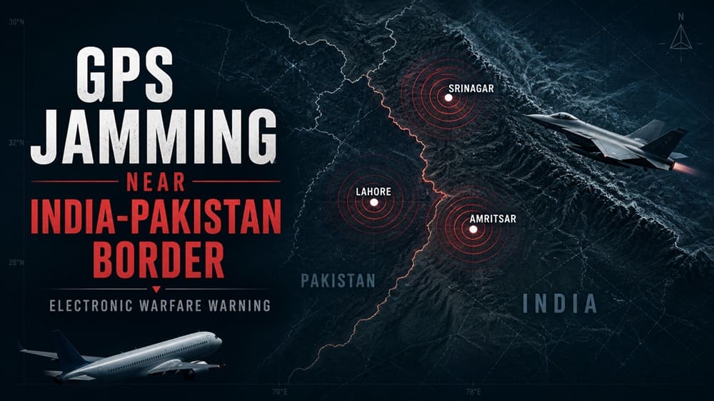
Intense GPS Jamming Near India-Pakistan Border
GPS jamming near the India-Pakistan border has become a serious electronic warfare/aviation issue. There have been reports of heavy GNSS jamming near Lahore, Amritsar, and Srinagar. These areas are close to sensitive air corridors, forward air bases, and heavily monitored military areas. Thus, even localized navigation failures can have broader operational impacts.
Pilots have been reporting signal loss, navigation errors, and unreliability in satellite positioning data. For commercial aviation, such issues create cockpit workload and route-planning headaches. But the problem is more serious for military applications. Modern air operations require accurate position, navigation, and timing data. “When that layer becomes unstable, the effectiveness of aircraft, drones, weapons, and tactical networks all goes down.”
Why GPS Jamming Matters
GPS signals are sent to the aircraft from satellites thousands of kilometres above the Earth. By the time those signals arrive, they are fragile. A ground-based jammer can flood them with more noise in the same frequency band. This makes it particularly challenging for the receiver to compute a favorable position.
The threat from spoofing is even more complex. Spoofing can inject false navigation data into a receiver instead of just jamming the signal. This can confuse aircraft systems, drone autopilots, and tactical positioning equipment. Therefore, GPS jamming on the India-Pakistan border should not be merely considered a technical fault. It could be part of a wider electronic attack environment.
Commercial aircraft have back-up systems still. Crews can use inertial navigation, ground-based aids, radar vectors, and air traffic control support. However, GNSS interference can also cause terrain alerts, increase fuel planning margins, and force pilots to avoid certain procedures. This problem worsens in the mountainous approaches near Srinagar, where terrain awareness is important.
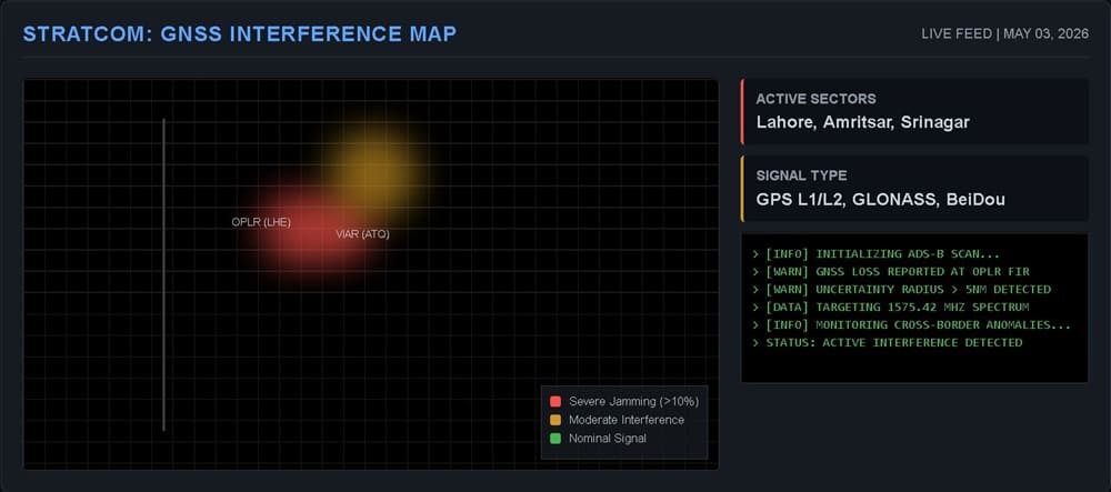
Why Lahore-Amritsar-Srinagar Matters
Lahore and Amritsar are on opposite sides of one of the world’s most militarized borders. Civil traffic is also in the airspace around both cities, and this airspace lies over high-value military geography. Srinagar’s location near disputed mountainous terrain adds another layer. Hence, any GNSS disruption in this triangle should be closely observed.
Aviation authorities will often issue NOTAMs when crews need to be aware of GNSS interference. These notices are not always clear about the source. But they warn pilots to prepare for navigation degradation. In a crisis-prone area, those warnings could indicate electronic warfare operations, defensive counter-drone efforts, or more general military readiness.
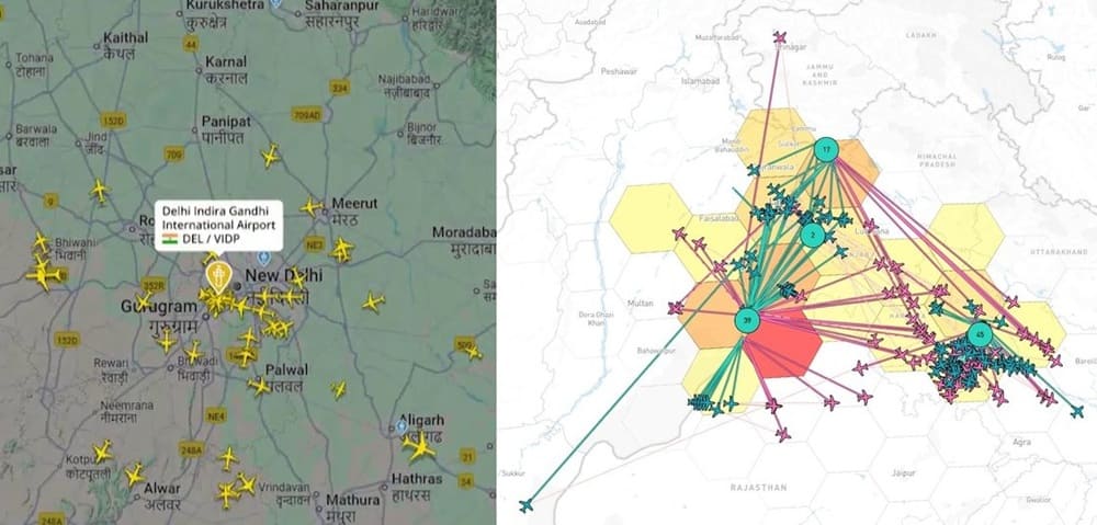
Commercial Flight Disruption
The first effect for airlines is operational disruption. Crews could see route changes, delayed approaches, or more ATC coordination. Airlines may also add fuel buffers when flying over affected regions. Flight management systems can also reject satellite inputs that appear to be unstable and revert to inertial systems.
The risk doesn’t mean planes are suddenly unsafe. Today’s airliners fly with many layers of navigation. But pilots do not like uncertainty in crowded or terrain-sensitive airspace. A false terrain warning, an unreliable position update, or a degraded approach mode can cause pressure inside the cockpit. Therefore, the aviation authorities should consider persistent GNSS jamming as a safety problem and not only as a military one.
Tactical Positioning Risks
The issue is different for military forces. GNSS is utilized in many other tactical systems besides navigation. It is used for time synchronization, blue-force tracking, drone control, precision weapons, artillery coordination, and networked command systems. If the timing layer breaks down, digital combat systems may lose coherence.
This highlights the strategic importance of GPS jamming along the India-Pakistan border. It can blind drones, degrade weapon accuracy, and complicate air mission planning. It can also lead pilots and operators to more old-school, manual techniques. In wartime, that change slows decision-making and increases human error.
Both India and Pakistan have experience in degraded environments. Their air forces are trained in radar-guided navigation, inertial drift management, and electronic countermeasures. Jamming may therefore not stop operations. It makes them pricier and more dangerous to execute.
Is This Linked to “Sindoor 2.0”?
The term “Sindoor 2.0” has entered the regional information space as a possible shorthand for renewed Indian military pressure. But open-source evidence does not support that current GNSS jamming is part of a planned IAF strike package. In the absence of stronger indicators, analysts should not assume jamming reports to be certain.
That said, electronic activity often ramps up prior to or during military signaling. Air forces might test radar discipline, enemy reactions, and communications patterns. They may also ban drones and precision-guided systems around sensitive areas. So the current pattern is worth watching.
If accurate, the reported PAF–IAF three-hour air jamming and evasion activity would be a significant escalation in the electromagnetic domain. But no credible public means have confirmed this activity. Look for supporting signs for defense watchers: strange tanker flights, airspace closures, fighter dispersal, emergency NOTAMs, air-defense alerts, and political warnings.
What to Expect Next
The key issue is not jamming alone. The real warning comes when GNSS disruption happens at the same time as military movement. The border could become more dangerous if electronic warfare, airspace restrictions, and political messaging come together.
Currently, GPS jamming along the India-Pakistan border signals an increased electronic warfare environment. It has implications for commercial aviation, makes tactical positioning harder, and raises questions about military readiness. However, that does not prove that a major operation is starting.
The obvious view is the most balanced. Both sides could be shaping the electromagnetic battlespace. India may be trying to apply pressure options. Pakistan may be tracking and countering them. Meanwhile, civilian aircraft still carry a share of the cost. In South Asia, the first sign of escalation might not be a missile launch. It could be dropping a navigation signal.
References
- https://skybrary.aero/articles/gnss-jamming-and-spoofing
- https://www.icao.int/sites/default/files/Meetings/a42/Documents/WP/wp_335_en.pdf
- https://www.icao.int/APAC/Pages/default.aspx
- https://notamify.com/